Draft CicLAvia October 2011 Expansion Routes South and East
May 23, 2011 at 2:25 pm Joe Linton 17 comments

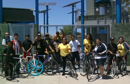
South L.A. expansion ride stops in front of the Council District 9 Constituent Center on Central Avenue
These aren’t one-hundred-percent finalized yet, but CicLAvia wants to share the draft expansion routes for South Los Angeles and Boyle Heights. The October/April CicLAvia route is shown in red. Expansion for Boyle Heights is blue; for South L.A. green.
CicLAvia has worked with community groups in these areas to form local host committees. Potential routes has been brainstormed, bicycled and refined. Nonetheless, the CicLAvia expansion host committees are still meeting with various folks and still finalizing these routes. It takes about four months for the permitting process, so the pretty-much-final versions will be submitted to the city in mid-June. Depending on funding, logistics, capabilities, these routes may be added in full or in part this October. If you want to see CicLAvia expand, please donate and/or sponsor!
South Los Angeles
CicLAvia has been working with a South L.A. Host Committee that includes leadership from TRUST South L.A., SAJE, Mercado La Paloma, and participation from quite a few other South L.A. groups. South L.A. is a big place – about 10 miles by 10 miles – and it became clear early on that CicLAvia couldn’t get to all of it on the first expansion. The priority for the initial expansion soon became connections with the Central Avenue Jazz corridor and Exposition Park, with later South L.A. phases to connect with the Watts Towers and with Leimert Park.
The draft South L.A. expansion extends south from the current CicLAvia route at 7th and Spring. It turns east onto 9th Street and extends through the Fashion District. At Central Avenue, it turns south. It hooks back westward at Vernon Avenue, wiggling onto San Pedro Street, Martin Luther King Blvd, Broadway Place and 39th Avenue, with a terminus at Exposition Park. It includes a short spur on Grand Avenue, connecting with Mercado La Paloma.
Some possible rest stops include: African American Firefighter Museum, A Place Called Home, Central Avenue Jazz Park, Council District 9 Constituent Center, Gilbert Lindsay Park, Mercado La Paloma, and Exposition Park.
To get involved in CicLAvia South L.A., join this googlegroup.
Boyle Heights / East L.A.
CicLAvia has been working working with a Boyle Heights Host Committee that includes participation from Roosevelt High School, Corazon del Pueblo, and many others. Boyle Heights is a lot smaller than South L.A. – only about 2 miles by 2 miles. Packed into that small footprint, there are lots and lots of great commercial corridors, and many historical and contemporary landmarks. There are also a few hills, train tracks and freeway off-ramps – things that CicLAvia routes avoid. The Boyle Heights committee ended up focusing mostly on First Street, with later eastward phases hopefully extending on Whittier Boulevard.
The draft Boyle Heights expansion extends nouth from the current CicLAvia route at 4th Street and Boyle Avenue. It turns east onto 1st Street at Mariachi Plaza. It connects with Evergreen Cemetery where it turn south on Evergreen and then jogs over to Euclid Avenue. It hooks east onto Whittier Boulevard with a terminus at L.A. County’s Salazar Park.
Some possible rest stops include: Mariachi Plaza, the Triangle Mini-Park (1st and Chicago), Evergreen Cemetery, Evergreen Park, and Salazar Park.
To get involved with CicLAvia Boyle Heights/East L.A., join this googlegroup.
Entry filed under: Uncategorized. Tags: Boyle Heights, South Los Angeles.
17 Comments Add your own
Leave a comment
Trackback this post | Subscribe to the comments via RSS Feed


1. Elson | May 23, 2011 at 2:53 pm
Why doesn’t the Eastside CicLAvia route go further up Evergreen so we can enjoy some El Tepeyac burritos? 🙂
I was under the impression that the South LA route would go as far as Watts – guess that will have to wait for a future CicLAvia!
But I like how there’s a linkage from Downtown. Most people don’t see a connection to South Los Angeles from DTLA except for major streets like Figueroa or Alameda.
If the local communities are cool with the new routes I say let’s go for it. The more CicLAvia, the better!
2. Collision maps reveal L.A.’s unsafe routes to school; more tragedy in pro cycling (and not just Lance) « BikingInLA | May 24, 2011 at 12:43 am
[…] looks at the art of riding in Santa Monica. CicLAvia wants to know what you think about the proposed expansion routes into Boyle Heights and South L.A. The Times looks at some unusual bike designs. Santa Monica riders review that city’s proposed […]
3. Streetsblog Los Angeles » Today’s Headlines | May 24, 2011 at 9:01 am
[…] CicLAvia Publishes Draft Routes for South L.A., Boyle Heights […]
4. Chris Loos | May 24, 2011 at 10:41 am
The route extension news is very exciting!
How about an extension westward from the current Heliotrope/Melrose terminus? While its important to create opportunities in places like Boyle Heights and South LA, I think another goal of Ciclavia should be to show those car-happy Westsiders that “there is another way”!
5. Douglas E. Welch | May 24, 2011 at 2:00 pm
I’d love to see something in the Valley. Maybe starting at Noho so the Red Line could act as a virtual extension if people want to do a big north-south ride.
How about a route up Chandler, Van Nuys and Sherman Way like the old trolley line ran. This was also one of the few car transport routes through the Valley back in the day?
6. July CicLAvia Canceled; October is a Go | Blogging.la | May 24, 2011 at 5:19 pm
[…] good news: CicLAvia is expanding into South Los Angeles and deeper into Boyle Heights. More room for more people doing more things. Sounds like this thing is a hit. Since you guys are […]
7. Andres Ramirez | May 24, 2011 at 6:28 pm
Cant wait for CicLAvia to come to South LA!! This will provide a great opportunity for our community to have some safe public outdoor space. It also provides the space to shed the bad rep our community gets from media and share the history and culture we give to this city. Next stops Watts and Leimert!!!
8. Ely Alexander | May 25, 2011 at 12:10 am
Can’t wait for this expansion! Our company Retrospec Bicycles fully supports this. Also, we will probably be hosting an after party downtown that evening!
9. sketchkat06 | May 25, 2011 at 11:32 am
Wow! I won’t know which new spur to explore first! Would love to head to the fashion district and stock up on some needed clothing, but would also love to see more of the Boyle Heights amazing residential architecture!
10. Alek F | May 25, 2011 at 12:27 pm
Folks,
can we extend the western part further into Hollywood??
The “LA City College” is almost like “middle of nowhere”… I strongly suggest the western end to be extended closer to Highland Avenue or even La Brea Avenue.
Thanks!
11. Ciclavia Update | Culver City Bicycle Coalition | May 25, 2011 at 2:54 pm
[…] the existing route by introducing new spurs: 1. South L.A. (including Fashion District, Central Avenue and Exposition Park) 2. Additional Boyle Heights […]
12. CicLAvia Heads East « Life « MIS NEIGHBORS | May 30, 2011 at 10:26 pm
[…] expansion ride,” and it was (minus the high winds that hit mid-afternoon). A small group met CicLAvia organizer Joe Linton at Libros Schmibros to ride the potential expansion route into Boyle Heights […]
13. Peggy Archer | June 4, 2011 at 4:02 pm
I agree that it would be great to see it expand northward and westward as well, but this is a very good start!
14. Ezra | June 15, 2011 at 5:35 pm
I am curious to know how the “T” intersections are going to work–with the speeds some cyclists are riding and the sheer numbers of riders of different ability levels, I hope that we won’t see more accidents and collisions. I had an accident at the last ciclavia that ended up with a hospital visit because of the speed of the other rider and my inattention–both are common at Ciclavia, I’m suprised it hasn’t happened more.
15. Joe Linton | June 16, 2011 at 9:54 am
I am curious to hear ideas from our readers on how T-intersections could work. Right now we’re focused on finalizing routes… and, soon, we’ll be looking at these T-intersections… I plan to check in with other ciclovia event leaders from other cities. My initial thought is to do a traffic circle – with some big signs with arrows to let folks know how to navigate the intersection, and which way to go toward specific destinations. I think we’re going to have to make the signs fairly large and put them fairly high… and probably station some volunteers at the roundabouts to help folks navigate.
16. Ezra | June 16, 2011 at 10:24 am
I like the idea of a traffic circle, as long as there is a no stopping or endless circling policy… I could see large groups circling around for fun, clogging the intersection.
But Traffic circles are great because they force people to slow down, which is good!
17. Josue | September 1, 2011 at 5:37 pm
i love the Boyle Height bike lane plane. I ride on 1st everyday and i know theres enough room for a bike lane. This will make everything more safe for me as a bike rider and everyone else.